Soil Science Ch 6. Soils of India
India's vast 328.7 million hectares support eight major soil groups. Each soil type represents a unique combination of parent material, climate, vegetation, relief, and time. For effective agricultural management and examination purposes, it is critical to know the area percentage, distribution states, texture, pH, organic matter content, fertility status, typical crops, and specific management challenges for each type.
6.1 Classification Systems Used in India
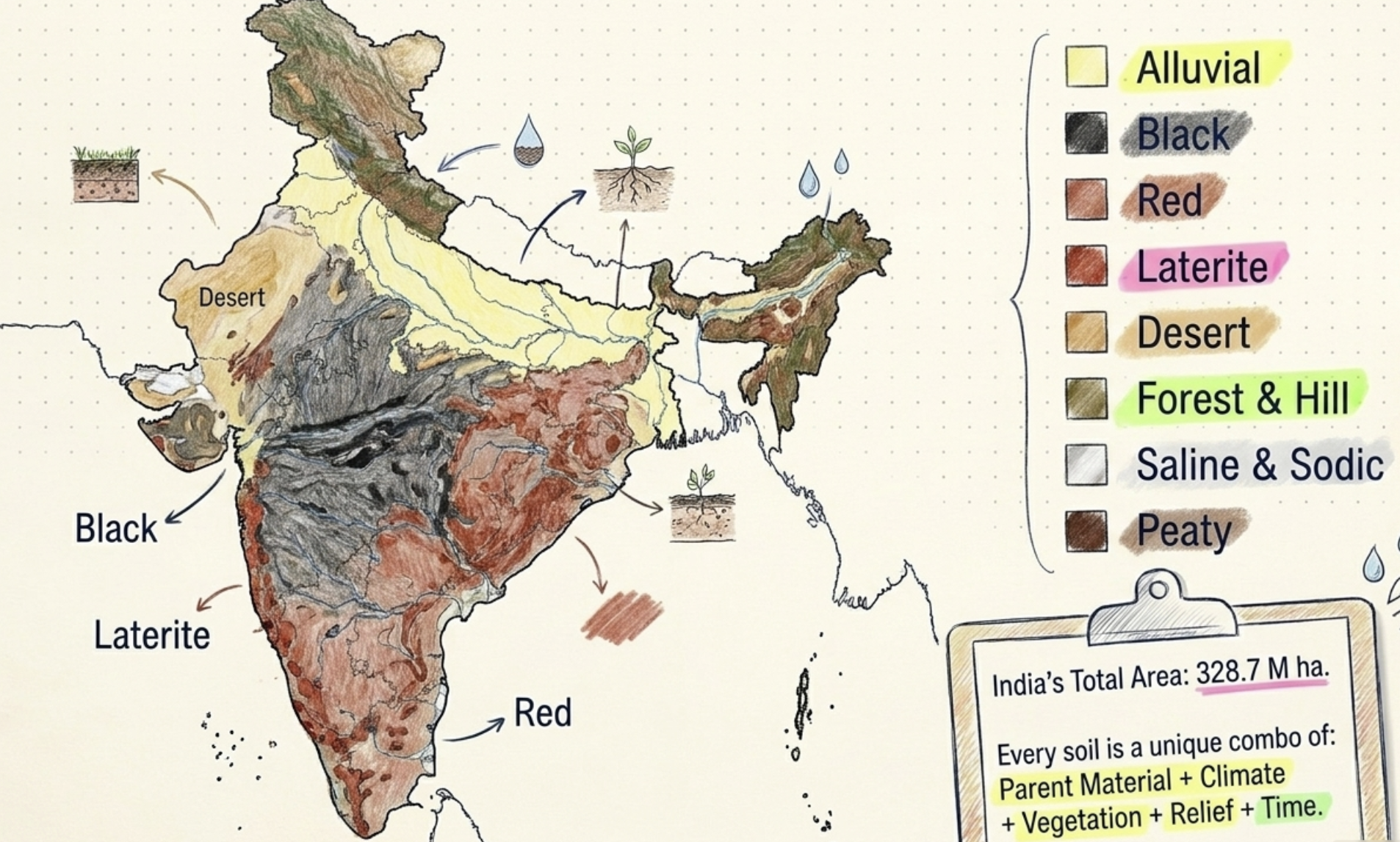
- ICAR Traditional Classification (8 Groups): This is the system most commonly used in Indian textbooks and agricultural extension programs. It categorizes soils into Alluvial, Black Cotton, Red, Laterite, Desert, Forest & Hill, Saline-Alkaline, and Peaty & Marshy soils.
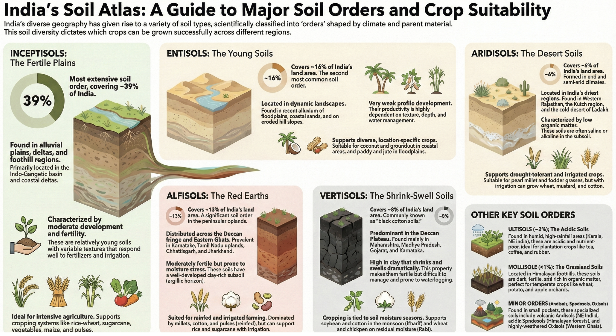
- USDA Soil Taxonomy (12 Soil Orders): India's soils have been scientifically mapped using this global system by the National Bureau of Soil Survey and Land Use Planning (NBSS&LUP) in Nagpur. The major orders found in India are Inceptisols (covering roughly 40% of the country), Entisols, Vertisols, Alfisols, Ultisols, and Aridisols.
- FAO-UNESCO System: Used for the World Soil Map, this system classifies India's soils into Cambisols, Luvisols, Vertisols, Nitisols, Arenosols, Solonchaks (saline soils), and Solonetz (sodic soils).
- NBSS&LUP (National Bureau of Soil Survey & Land Use Planning): Located in Nagpur, this bureau published the definitive National Soil Atlas of India, which serves as the authentic reference for soil distribution across the country.
6.2 Alluvial Soils — Inceptisols / Entisols
A. Distribution and Formation
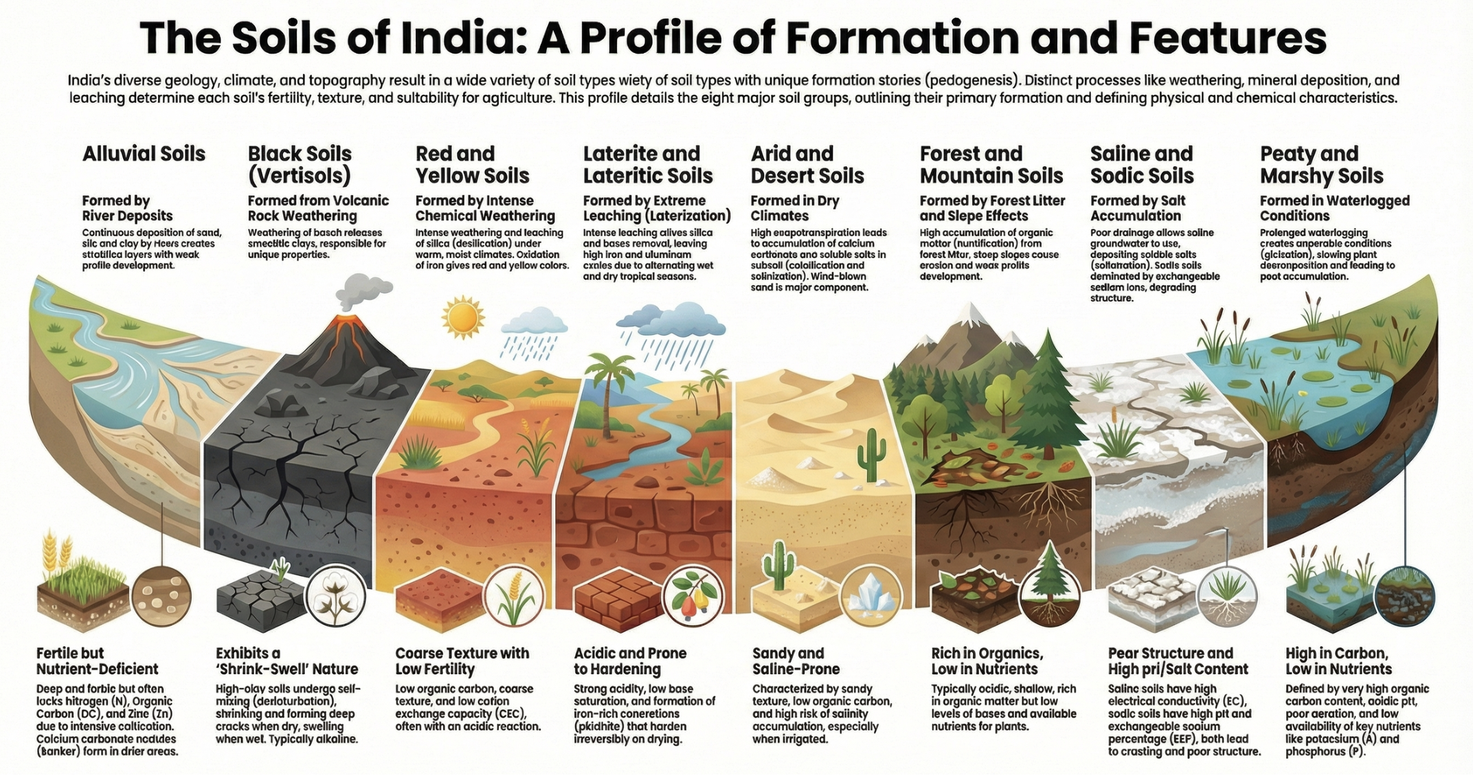
Alluvial soils cover approximately 78 million hectares, making up about 24% of India's geographical area. This makes them the largest single soil type in the country. They are distributed primarily across the Indo-Gangetic Plains (Punjab, Haryana, Uttar Pradesh, Bihar, West Bengal), the Brahmaputra Valley in Assam, and all major coastal and deltaic plains. Unlike soils formed in place, alluvial soils are formed from transported parent material carried and deposited by major river systems (Indus, Ganga, Brahmaputra, Godavari, Krishna, Cauvery) over millions of years.
B. Sub-classification
- Khadar (New/Young Alluvium): These soils are deposited in active floodplains adjacent to rivers. They are light-colored (pale or yellowish-grey) with a sandy to loamy texture. Because they are renewed annually by fresh floods, they receive constant deposits of new nutrients, making them highly fertile.
- Bhangar (Old Alluvium): Found on elevated alluvial terraces above the active flood level. These are older soils with a heavier texture and often contain 'kankar' (nodular CaCO₃ concretions). They are slightly weathered and are less frequently renewed by floods. They make up most of the agricultural land in Punjab and Haryana.
C. Physical and Chemical Properties
- Texture: Highly variable, ranging from sandy near the riverbeds to clayey in deltaic regions furthest from the rivers. The most fertile zones feature a balanced loamy texture.
- Structure: Generally weak to moderate, as these are biologically young soils. However, their structure improves significantly with the addition of organic matter.
- Organic Matter: Ranging from 0.3 to 1.5%, the organic matter is generally low to moderate. It is highest in the humid eastern belts (Bihar and West Bengal) and lowest in the dry northwest (Punjab and Haryana).
- pH: Ranges from 6.5 to 8.5. It is near-neutral in the humid east and slightly alkaline in the drier northwest, directly varying with regional rainfall and leaching patterns.
- Nutrient Status: Rich in potassium due to an illite-mica mineral base, and moderate in nitrogen and phosphorus. However, there is a widespread zinc deficiency; over 50% of these soils became zinc-deficient following the intensive farming of the Green Revolution.
D. Agricultural Significance and Management
Alluvial soils are the most productive soils in India, supporting roughly 60 to 70% of the country's total foodgrain production. They support an incredibly diverse range of crops, including rice, wheat, sugarcane, potatoes, vegetables, maize, cotton, oilseeds, and pulses. Their flat terrain, deep soil profile, accessible groundwater, and high responsiveness to fertilizers made the Green Revolution possible.
Current management challenges include severe groundwater over-extraction (with water tables in Punjab and Haryana falling rapidly), secondary salinization in poorly drained canal command areas, widespread micronutrient depletion, and plummeting organic matter levels due to crop residue burning. Management requires crop diversification, regular zinc sulfate application, strict residue incorporation instead of burning, and the adoption of micro-irrigation.
6.3 Black Cotton Soils — Vertisols (Regur Soil)
A. Distribution and Formation
Covering roughly 27 million hectares (8% of India), these soils dominate the Deccan Plateau, including central Maharashtra, western Madhya Pradesh, parts of Gujarat, northern Karnataka, southern Andhra Pradesh, and eastern Rajasthan. They are formed by the in-situ weathering of Deccan Trap basaltic rock under moderate rainfall. This magnesium, iron, and calcium-rich basalt weathers to form montmorillonite, a 2:1 expanding clay mineral. They are locally known as Regur, Tropical Black Earth, or simply Black Cotton Soil.
B. Characteristic and Unique Features
- Color: Ranging from dark grey to deep black. Importantly, this color comes from titaniferous magnetite (an iron-titanium mineral from the basalt), not from organic matter.
- Clay Content: Extremely high, containing 50 to 80% clay dominated by montmorillonite.
- Shrink-Swell Behavior: These soils undergo massive volume changes (50 to 100%) between wet and dry states. They expand heavily on wetting and shrink on drying, forming deep, wide cracks in the dry season.
- Self-Mulching (Self-Tilling): During the dry season, surface material falls into the deep cracks. When the rains return and the soil swells, it naturally mixes this material, acting as a natural ploughing mechanism.
- Slickenslides: Polished, grooved surfaces hidden within the soil profile, created by the internal stress and friction of the soil swelling and rubbing against itself.
- Moisture Retention: They possess a very high Field Capacity, allowing crops to survive 4 to 6 weeks without rain, making them exceptional for deep-rooted rainfed agriculture.
C. Chemical Properties
- pH: Ranges from 7.0 to 8.5 (neutral to moderately alkaline). Some sodic black soils (known as 'kali matti' or black alkali) can reach a pH of 9 to 10.
- CEC and Base Saturation: They possess a remarkably high CEC (40 to 80 cmol/kg) due to the montmorillonite clay. Base saturation is excellent (80 to 95%), heavily dominated by calcium, making them naturally fertile for basic crop nutrients.
- Organic Matter: Surprisingly low (0.5 to 1.5%) despite the dark color, due to rapid decomposition in the humid season and continual harvest removal.
- Nutrient Status: Nitrogen is generally low due to slow mineralization. Phosphorus is often fixed as calcium phosphate (Ca-P) due to the high pH. Micronutrient deficiencies in iron, zinc, and manganese are common, frequently causing iron chlorosis in crops like soybeans.
D. Agricultural Significance and Management
Major crops include cotton, sorghum (jowar), chickpeas (gram), groundnuts, and soybeans. Their excellent moisture storage makes them ideal for rainfed farming. However, tillage timing is incredibly strict; farmers must till at exactly the right moisture level, often using a broad-bed furrow system to improve drainage and prevent waterlogging. Regular additions of farmyard manure (FYM) or green manure are essential to improve structure and phosphorus availability.
6.4 Red Soils — Alfisols / Ultisols
A. Distribution and Formation
Red soils are the second-largest group in India, covering about 60 million hectares (18% of the country). They cover the Peninsular plateau, including Telangana, eastern Andhra Pradesh, interior Karnataka, Tamil Nadu uplands, Chhattisgarh, Jharkhand, and Odisha. They form from the in-situ weathering of crystalline igneous and metamorphic rocks (like granite and gneiss) under moderate rainfall and good drainage.
B. Properties
- Color: Bright red to reddish-brown due to the dominance of hematite (Fe₂O₃). In less well-drained areas, goethite dominates, giving a yellow-brown tint.
- Texture and Structure: Ranging from sandy loam to clay loam, they generally have a weak to moderate granular structure at the surface and a blocky structure in the subsoil.
- pH: Slightly to moderately acidic (5.5 to 7.0) due to the natural leaching of basic cations.
- Organic Matter and CEC: Both are very low. Organic matter hovers around 0.5 to 1.0% due to rapid decomposition in hot climates. The CEC is low (8 to 18 cmol/kg) because the dominant clay mineral is kaolinite.
- Nutrient Status: Generally deficient in nitrogen, phosphorus (which is heavily fixed by iron and aluminum at acidic pH levels), calcium, and magnesium.
C. Agricultural Use and Management
Finger millet (ragi) is a primary crop, alongside groundnuts, tobacco, pulses, castor, and irrigated horticulture. The main limitations are poor water retention (leading to drought stress) and high phosphorus fixation. Management requires heavy organic inputs (5 to 8 t/ha of compost), liming for highly acidic patches, strict contour farming to prevent erosion, and micro-irrigation to maximize horticultural yields.
6.5 Laterite Soils — Oxisols / Ultisols
A. Distribution and Formation
Though they cover a limited area of 13 to 14 million hectares, laterite soils are economically vital for plantation crops. They are found in high-rainfall coastal regions like Kerala, coastal Karnataka, Goa, the Meghalaya plateaus, and the Eastern Ghats of Odisha. They are the result of extreme tropical weathering under intense rainfall (greater than 2000 mm). This relentless leaching removes all silica and basic nutrients, leaving behind a residual concentration of iron and aluminum oxides.
B. Properties and Characteristics
- Color and Texture: Deep red to reddish-brown, with a clay to clay-loam texture dominated entirely by non-expanding kaolinite clay.
- Irreversible Hardening: This is the defining feature of laterite. When exposed to the air and alternating wet-dry cycles, the iron compounds re-cement the soil into rock-hard ironstone (plinthite or ferricrete). This process is irreversible, severely damaging farm implements, though the hardened blocks are highly prized as building materials in Kerala and Goa.
- Chemical Status: Strongly acidic (pH 4.5 to 6.0), carrying a severe risk of aluminum toxicity. Because they consist mostly of kaolinite and iron oxides, their CEC is incredibly low (5 to 12 cmol/kg), and they are profoundly deficient in almost all essential plant nutrients.
C. Agricultural Use
Because of their high acidity and low natural fertility, they are used almost exclusively for acid-tolerant plantation crops like rubber, coconut, tea, coffee, black pepper, and cardamom. Cultivating field crops requires massive inputs, including high lime applications (4 to 6 t/ha) and heavy organic manuring. Crucially, farmers must never deep-plow or expose the subsoil, as this triggers irreversible hardening.
6.6 Desert (Arid) Soils — Aridisols
Covering roughly 28 to 32 million hectares, these soils dominate the Thar Desert in western Rajasthan, extending into Kutch, Haryana, and the arid fringes of Punjab. Formed from wind-blown (aeolian) sand under negligible rainfall, they experience almost no chemical weathering or leaching. Consequently, salts, calcium carbonate, and gypsum accumulate heavily, often forming hard 'kankar' (caliche) layers deep in the profile.
They are pale yellow to light brown, highly sandy, and extremely porous with very poor water retention. They are strongly alkaline (pH 7.5 to 9.0) with virtually zero organic matter or nitrogen. Under irrigation, farmers grow pearl millet (bajra), wheat, cumin, mustard, and castor. Management relies heavily on stabilizing sand dunes with shelterbelts (like Prosopis and Eucalyptus) to prevent wind erosion, and using highly efficient drip or sprinkler irrigation to prevent secondary salinization.
6.7 Forest & Hill Soils
Covering 27 million hectares across the Himalayas, the Eastern and Western Ghats, and the Satpura-Vindhya ranges, these are fragile, highly biodiverse soils formed in-situ under dense forest cover.
They boast the highest organic matter content of any Indian soil (5 to 10% under undisturbed conditions), which gives them an excellent granular structure and a sponge-like water-holding capacity. They are naturally acidic (pH 4.5 to 7.0) due to organic acids leaching from the heavy leaf litter. Under natural closed-loop forest conditions, nutrient cycling is perfect. However, if the forest is cleared for agriculture, these soils degrade rapidly. They support high-value crops like apples in the Himalayas and tea/coffee in the Ghats, but absolutely require strict terrace farming and forest conservation to prevent catastrophic erosion.
6.8 Saline & Sodic Soils
These are severe problem soils. Roughly 5.5 to 7 million hectares are severely affected, with another 10 million moderately affected, leading to massive agricultural losses. They are found scattered across the Gangetic plains of UP ('usar' lands), canal command areas in Haryana and Punjab, the Rann of Kutch, and various coastal regions. They form naturally in low-lying depressions or artificially through over-irrigation and poor drainage, which causes the water table to rise and deposit salts on the surface via capillary action.
- Saline Soils: Defined by an Electrical Conductivity (EC) > 4 dS/m and a pH < 8.5. They usually have a visible white crust of chlorides and sulfates, though their physical structure remains intact. Reclaimed by heavy leaching with fresh water and installing subsurface drainage.
- Sodic Soils: Defined by an Exchangeable Sodium Percentage (ESP) > 15% and a pH > 8.5. They have no visible salt crust but contain toxic Na₂CO₃, which completely destroys the soil structure, often forming impenetrable columns. Reclaimed by applying 5 to 10 t/ha of gypsum to displace the sodium, followed by leaching.
Before full reclamation, farmers are forced to grow highly salt-tolerant halophytes or specific crops like barley and sugarbeet.
6.9 Peaty & Marshy Soils
Covering a small but ecologically unique area of 1.5 million hectares, these soils are found in the Kerala backwaters (the famous Kuttanad region), the Sunderbans mangroves of West Bengal, and various floodplains. They form under permanently or seasonally waterlogged conditions where a lack of oxygen severely retards microbial decomposition, leading to the massive accumulation of peat and muck over centuries.
They possess incredibly high organic matter (20 to 30%, sometimes reaching 90% in pure bogs) and are highly acidic (pH 4.0 to 5.5). While they hold vast amounts of locked nitrogen and phosphorus, their physical structure is poor, with high compressibility and severe subsidence if drained. Agriculturally, they are famous for supporting below-sea-level rice cultivation in Kuttanad. Environmentally, they are massive carbon sinks; draining them releases centuries of stored carbon as CO₂, making their conservation a critical climate priority.
6.10 Quick Reference Summary — Major Soil Types
- Alluvial: 78 M ha (Largest). Found in IGP and coasts. Loamy texture, pH 6.5–8.5, low OM (0.5–1.5%). Supports all major crops. Most productive soil in India.
- Black Cotton: 27 M ha. Found in the Deccan Plateau. Heavy montmorillonite clay, pH 7.0–8.5, low OM. Excellent for cotton and rainfed sorghum. Highest natural fertility and water retention.
- Red Soils: 60 M ha. Found in the Peninsular plateau. Sandy to clay loam, acidic pH 5.5–7.0, low OM. Supports ragi and groundnuts. Moderate fertility, high P-fixation.
- Laterite: 13 M ha. Found on high-rainfall coasts (Western Ghats). Clay texture, highly acidic pH 4.5–6.0, moderate OM. Supports rubber, tea, and spices. Very low fertility; hardens irreversibly.
- Desert: 30 M ha. Found in Rajasthan. Highly sandy, alkaline pH 7.5–9.0, almost zero OM. Supports bajra and irrigated mustard. Very low inherent fertility; high wind erosion risk.
- Forest/Hill: 27 M ha. Found in the Himalayas and Ghats. Acidic pH 4.5–7.0. Highest OM (5–10%). Supports apples and tea. Highly fragile ecosystem.
- Saline/Sodic: 6–10 M ha. Scattered across canal and coastal areas. High pH (>8.5) and high salts. Problem soils requiring intensive chemical reclamation.
- Peaty: 1.5 M ha. Found in Kerala and Sunderbans. Highly acidic (pH 4.0–5.5). Massive OM (>20%). Unique, fragile carbon sinks supporting specialized rice.
📝 Exam Focus / Past Year Question (PYQ) Hooks
- PYQ 2025 Q2(c) 10M: Brief note on major soils of India. → Utilize the 6.10 Quick Reference Summary to structure your answer. Pick 4 to 5 major soils (e.g., Alluvial, Black, Red, Laterite, Desert). Write about 40 to 50 words per soil, highlighting the area, geographical distribution, one key unique property (like shrink-swell for Black soil or irreversible hardening for Laterite), and the primary crops grown. This will easily yield a concise, high-scoring 250-word response.